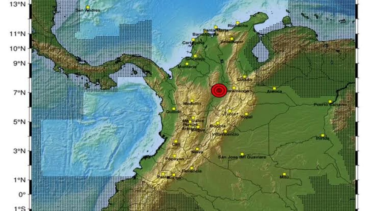
In the early hours of Friday, January 16, 2026, seismic monitoring systems of the Colombian Geological Service (SGC) detected a significant seismic event that was felt across several departments in the country, particularly in the northeast. The earthquake occurred at 02:05 local time and reached a magnitude of 5.0, as per the preliminary bulletin issued by the entity.
The epicenter was located in one of the most seismically active areas of the world: the Santander department. Historically, this region hosts the so-called Bucaramanga Seismic Nest, primarily situated beneath the municipality of Los Santos.
Despite the intensity of the tremor, which caused alarm in high-rise buildings and residential areas, the authorities from the National Unit for Disaster Risk Management (UNGRD) immediately initiated the verification protocol in municipalities near the epicenter. So far, reports from local rescue and fire services do not indicate serious structural damage or human casualties, although monitoring for possible aftershocks continues.
Tremor in Mexico Today
Meanwhile, another tremor was felt in Mexico, recorded with a magnitude of 5.3, prompting many citizens to take to the streets. President Claudia Sheinbaum, shortly after the earthquake, sent a message of reassurance via her account on X: “So far, no damages have been reported from the preliminary 5.2 magnitude quake registered at 00:42 with an epicenter in San Marcos, Guerrero. The National Coordination of Civil Protection is starting the review protocol.”
Earthquake in Honduras
As a complementary event to the tectonic activity of the day, the SGC also reported an international seismic event that occurred just one hour before the tremor in Colombia. At 01:08 local time (Central America time zone), a strong earthquake was recorded in Cuyamel, Honduras, with a magnitude of 5.2. Unlike the Colombian event, which typically occurs at intermediate depths in Santander, this one was of a shallow nature (less than 30 kilometers deep).
The shallow depth of the earthquake in Honduras suggests that the energy released is felt more sharply in the epicenter area, potentially affecting communities in the Cortés and Santa Bárbara departments, as well as border areas with Guatemala. This information was sourced from the United States Geological Survey (USGS), processed and disseminated by the SGC within its regional monitoring protocols.
Geological Context and Prevention Measures
The coincidence of these two events in the same early morning highlights the tectonic complexity of the region. While Colombia sits at the intersection of the Nazca, South American, and Caribbean plates, Central America is influenced by the subduction of the Cocos Plate beneath the Caribbean Plate.
The Colombian Geological Service reminds the public that the country is seismically very active, making such events expected. The information provided in the initial bulletins is of an automatic nature and subject to change after the final technical review. The public is advised to:
- Remain calm: Earthquakes cannot be predicted, but preparation reduces risk.
- Secure belongings: Ensure that pictures, shelves, and lamps are properly secured to prevent falls during seismic activity.
- Follow official sources: Stick to reports from the SGC and local response agencies to avoid misinformation.